
Demonstration Sites
A series of 17 demonstration sites of cropland and grassland located in contrasting climatic and environmental conditions have been identified around the world thanks to collaboration with local partners. Since 2013, a number of field campaigns have been achieved over these sites providing a large volume of ground measurements and about 20 high resolution maps used to validate the satellite-derived LAI, FAPAR and FCOVER of the Copernicus Global Land service. The ground dataset and the resulting maps are available here.
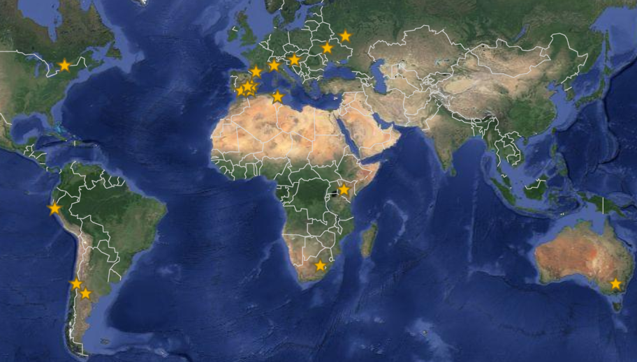
Maps of ImagineS demonstration sites
| ID | Name | Description | Location | Collaboration |
| 1 | South-West, France | Flat cropland with a rotation of wheat, maize, sunflower. Some fields are irrigated. | 43° 29’ N, 1° 16’ E | CESBIO |
| 2 | Hegyhatsal, Hungary | Flat cropland where small parcel-based agricultural management is typical of the whole country | 46° 57’ N, 16° 39’ E | ELU |
| 3 | Las Tiesas Farm, Barrax, Spain | Flat cropland of 65% dry land (barley, wheat) and 35% irrigated crops with large pivots (onion, garlic, sugarbeets, potatoes, maize, alfalfa, sunflower). | 39° 02’ N, 2° 04’ W | IFAPA |
| 4 | Tula, Russia | Typical field size is near 100 hectares. Crop types are winter wheat, spring barley, potatoes, maize, rape seeds, and winter rye. | 53° 05’ N, 37° 14’ E | DSSI |
| 5 | Upper Tana Basin, Kenya | Small holder farms where grow tea, coffee, maize and vegetables | 0° 55’ N, 36° 47’ E | CIAT |
| 6 | Merguellil, Tunisia | Flat plain with fields of cereals, vegetables and olive trees, dry and irrigated | 35° 45’ N, 10° 5’ E | CESBIO |
| 7 | Free State Province, South Africa | Agriculture and grasslands. Site located in the major grain producing province of South Africa. | 28° 25’ S, 27°4’ E | NEOSS |
| 8 | Greenbelt Farm, Ottawa, Canada | Agriculture in this region of eastern Canada mainly consists of corn, soybean and spring wheat annual crops adapted to short-season, perennial forage and livestock pasture. | 45° 18’ N, 75° 45’ W | Agri-Food |
| 9 | San Fernando, Chile | Flat cropland area covered by annual crops such as maize, wheat, alfalfa, sunflowers. | 34° 42’ S, 71° 0’ W | University of Chile |
| 10 | 25 de Mayo, La Pampa, Argentina | Semi-desertic area with irrigated alfafa pastures | 37° 54’ S, 67° 44’ W | INTA |
| 11 | Yanco area, Murrumbidgee River catchment, Australia | A gently sloping area containing irrigated croplands and natural rangelands. | 34° 45’ S, 146° 04’ E | University Monash |
| 12 | Comunidad de regantes del Campo de Cartagena, Spain | 50.000ha irrigated crops with drip irrigation (vegetables and citrus trees) | 37° 48’ N, 1° 03’ W | IFAPA |
| 13 | Cordoba, Spain | Flat cropland area | 37° 48’ N, 4° 44’ W | IFAPA |
| 14 | Lambayeque, Peru | Flat cropland area monitored for drought and desertification analysis | 6° 47’ S, 79° 46’ E | Universidad Nacional Mayor de San Marcos |
| 15 | La Albufera, Spain | Rice fields | 39° 16'N, 0° 19'W | University of Valencia |
| 16 | Rosasco, Milan, Italy | Rice fields | 45° 15'N, 8° 33'E | IREA |
| 17 | Pshenichne, Ukraine | Flat area with winter wheat, spring barley, maize, soy beans, winter rapeseed, sunflower, sugar beet, potatoes, winter rye and spring wheat | 50° 4'N, 30° 6'E | NAS |
ImagineS demonstration sites characteristics and collaboration.
France and Hungary are the main areas of interest as the regional Land Data Assimilation System can run at 8 km resolution over these countries.
The feasibility of the crop map merging Sentinel-1, Landsat-8 (as proxy of Sentinel-2) and PROBA-V (as proxy of Sentinel-3) has been demonstrated over two areas of 300km x 300km around Tula (Russia) and in the Free State Province (South Africa). Both are official sites of the
JECAM initiative, developed in the framework of GEO Global Agricultural Monitoring, which enables to share experiment data on proposed sites where regularly field campaigns are organized.